
PoliMappers at the Architecture for Smart City Course
- Federica Gaspari, Politecnico di Milano
- Oct 22, 2020
- 4 min read
PoliMappers is a student association founded at Politecnico di Milano (Italy) in December 2016. It is the first YouthMappers European chapter and, since its creation, the main mission of the group has been to train and inspire the next generation of mappers by organizing monthly events and trainings (both remote and in situ mapathons) dedicated to the university but also to primary and secondary schools, and focused on humanitarian and collaborative mapping through free and open source software.
After the successful Humanitarian collaborative mapping collaboration in the context of PoliMi innovative teaching programmes in 2019, this year PoliMappers had another great opportunity to introduce new and interested people to the world of geospatial collaborative projects in the university campus of Piacenza. Vice-president Alessandro Zacchera and Communication responsible Federica Gaspari took part in a series of lectures and webinars of Architecture for Smart City, a course organised by Professor Massimo Tadi and IMM DesignLab as part of the Master program in Sustainable Architecture and Landscape at Piacenza PoliMi Campus. Candan Eylül Kilsedar PhD., PoliMappers faculty advisor, and Arch. Carlo Andrea Biraghi PhD., academic tutor of the course, coordinated the collaboration.
On May 18, 2020, the first webinars of this collaboration took place remotely and saw the participation of almost 80 students. In these lectures, PoliMappers introduced the YouthMappers community, explaining its aims and activities. Then, the role of Volunteered Geographic Information was discussed in the context of citizen science, focusing in particular on OpenStreetMap as one of the core collaborative projects of our student association. In conclusion, our members illustrated the basics of contribution to Mapillary, the crowdsourced service that students were asked to use to perform on-field activities in the city of Piacenza. Students were then divided into groups and a specific area of Piacenza city was assigned to each group. Their task was to capture street level imagery in the urban environment and then upload them on the Mapillary platform. All the collected data were essential for the second part of the collaboration that required the joint use of Mapillary and OSM iD Editor for mapping shop places.
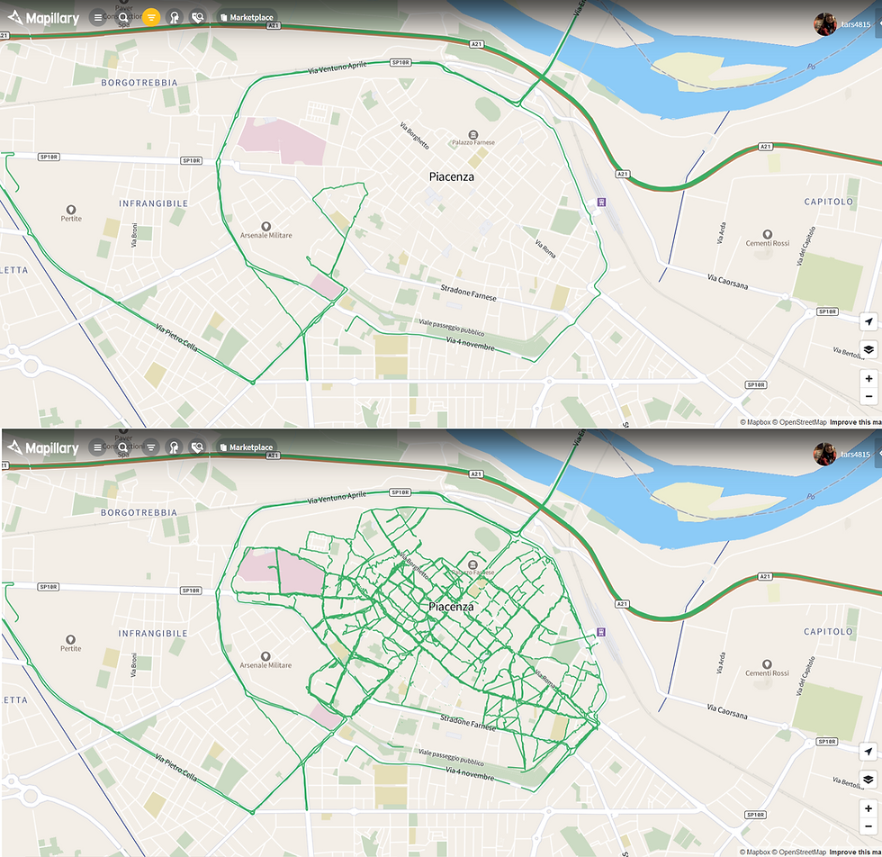
Piacenza Mapillary coverage before and after the PoliMappers activities
After a week of on-field image collecting, the second meeting took place on May 25, 2020. This part started with a presentation about the possible basic editing options of both Mapillary and OpenStreetMap. Then, before diving into the training on how to use the contributed data for updating OSM data, students shared their thoughts and views on the previous activities, highlighting even the most challenging moments they experienced while collecting images around the city. It is important to notice that all the activities were performed respecting the active measures and social distancing rules required after the COVID-19 lockdown period to which Italy was subjected in March and April.
The impressive amount of newly collected Mapillary data was then used as input for the training for adding shop places and tags on OpenStreetMap. At that point, students were asked to look carefully at the captured images to detect and map existing features, adding to the changeset comments the hashtags #PoliMappers, #YouthMappers and #A4SC. At the end of the second day, participants also attended a final webinar on how to extract OSM geodata using Overpass turbo and QuickOSM.

OSM activities of the city of Piacenza after the trainings
In less than two weeks, more than 600 #PoliMappers changesets and more than 1000 map changes were reported in the area of Piacenza. This incredible result was made possible by the valuable contribution of 32 students registered on OSM that updated the existing map database with the Mapillary observations collected by each group.
In conclusion, this project represented an incredible and enriching experience under many points of view. First, through this collaboration, students may have discovered new free and open source platforms, perfect for collaborative projects also in the field of urban studies. Indeed, tools like OpenStreetMap and Mapillary are ideal instruments for documenting and tracking the change and evolution of the urban environment and this aspect represents a crucial element for the conception of smart cities of the present and of the future too.
Also, PoliMappers learned a lot from the ideas and experiences shared by all the students that gave a different and new perspective to the OSM collaborative project.
We hope that this collaboration will lead to other great opportunities for PoliMappers and that our experience with this project will give useful inspirations to other YouthMappers chapters. Thanks to all the collaborators that made these events possible!
Here you can find all the materials and presentations used for this collaboration.
If you’re interested in any kind of collaboration with us, we will be really happy to organise something together. Please contact us at polimappers@gmail.com or write us on our social media channels: Facebook, Instagram and Twitter. More info on our website.

Federica Gaspari is the Social Media and Communication responsible and one of the founders of PoliMappers, the first European chapter of YouthMappers based in Politecnico di Milano (Italy). She studied Environmental and Land Planning Engineering at PoliMi, where she obtained her Master of Science in 2020.


Subway Surfers City offers a feeling that is both familiar and fresh. High-speed runs combined with upgrade and exploration systems make each playthrough different.
The notion of smart cities, both now and in the future, relies heavily on tools like OpenStreetMap and Mapillary, which are perfect for dordle recording and monitoring the development of metropolitan areas.