
COMMUNITY MAPPING TO IMPROVE FLOOD PREPAREDNESS AND DISASTER RISK REDUCTION
- Iliya Philemon Mato || 2023 YouthMappers Fellow || University of Jos YouthMappers
- Jun 14, 2024
- 5 min read
Updated: Jan 13, 2025
"Emergency preparedness is a team sport." Eric Whitaker.
Natural hazards cannot be prevented, but we can arm ourselves with knowledge to mitigate the impact of disasters that accompany such hazards. No one can solve the world's problem alone, but every action counts and the products of our actions will always be greater than the sum. Flood disasters have become a reoccurring event causing significant losses to lives and properties.
IOM (2022) reports that floods displaced 245 people and more than 2000 people were affected in Gangare and Rikkos communities of Jos North Plateau State, Nigeria. Daily Trust on 1st September, 2022 reports that over 50 houses had been destroyed in Jos North. For more than a decade, the affected communities has been experiencing incidence of flooding. In 2012 for example, at least 35 people lost their lives and more than 200 houses were destroyed - when we asked the ward head of Gangare about this he said, he recalled "49 persons were confirmed death from this incidence". No doubt, human induced Climate Change, heavy rainfall and river overflow are the major causes of floods in these communities, however, poor waste management and poor drainage systems contributes immensely to flood Disasters in this area.
The importance of open geospatial data in flood risk preparedness and disaster response planning cannot be over-emphasized. It helps Government Agencies, Humanitarian Organizations, Emergency Response Agencies, and other Development Partners to measure the impact of floods and to provide relief and other post-disaster interventions. Despite the enormous benefit of geospatial data and the seasonal occurrence of floods in these communities, very little open data is available in this area.
It is in view of this that the University of Jos YouthMappers, in collaboration with Geohazard Risk Mapping Initiative (GRMI), organize this mapathon to fill in the missing geospatial data critical for pre-disaster planning, early warning actions, and post-disaster (recovery and rebuilding) stage.
Mapping of roads and buildings via OpenStreetMap and field data collection on points of Interest related to flood and access to amenities, we contribute to ensuring that free and open geospatial data is readily available to humanitarian organizations, national and state emergency management agencies, research institutions and other stakeholders for prompt interventions and informed decision making that will effectively reduce the impact of floods and increase the resilience capacity of vulnerable communities.
In line with target "G" of the Sendai Framework for Disaster Risk Reduction: "Substantially increase the availability of and access to multi-hazard early warning systems and disaster risk information and assessment to people by 2030". Also, one of the framework's four priorities is "Enhancing disaster preparedness for effective response and to "Build Back Better" in recovery, rehabilitation and reconstruction". On this note, the project becomes crucial as it's the path to achieving the targets and priorities. Also, we believe that this project, "COMMUNITY MAPPING TO IMPROVE FLOOD PREPAREDNESS AND DISASTER RISK REDUCTION", will contribute to the achievement of Sustainable Development Goal 13 for Climate Action and Goal 11 for Sustainable Cities and Communities.
The Mapathon

Just like any other party, a map party requires planning and organization. Thanks to the blog post on hosting a mapathon published by missing maps and fellow YouthMappers.
LESSONS LEARNED
You can never be too prepared; always check and recheck that everything is working fine.
You can have multiple Internet Service Providers in case of poor connection, you can easily switch networks.
If you are in a place with unstable electricity, always have a backup power source.
When hosting an in-person event, always have control of the venue hours before the event so you can correctly set up and settle in before your participant start coming.
Create your project on the tasking manager a few days before the date and confirm that it is set correctly, your preferred hashtag is correctly entered and I'll advise you to do some testing mapping before the event.
The mapathon was hosted online and in person, with 20 in-person attendees and more than 30 online participants.


Online Mapathon
Taiwo Ogunwumi, the President and founder of GRMI, gave the opening remark: introducing the flood situation in Nigeria and highlighting the importance of digitizing buildings, road networks, and infrastructures as an element of flood preparedness and response. After him, our faculty mentor Dr Elijah Akintunde gave a geographic overview of Jos North and the flood situation in the Gangare and Rkkos communities. The third presentation was an overview of mapping with JOSM delivered by the President University of Jos YouthMappers, Iliya Philemon Mato, after which participants were allowed to contribute to the project.
Field data collection
Before going to the field, be clear on your specific objectives, and while on the field, work closely with community and youth leaders because their support is vital to the success of the field data collection and to ensure a bottom-up approach.

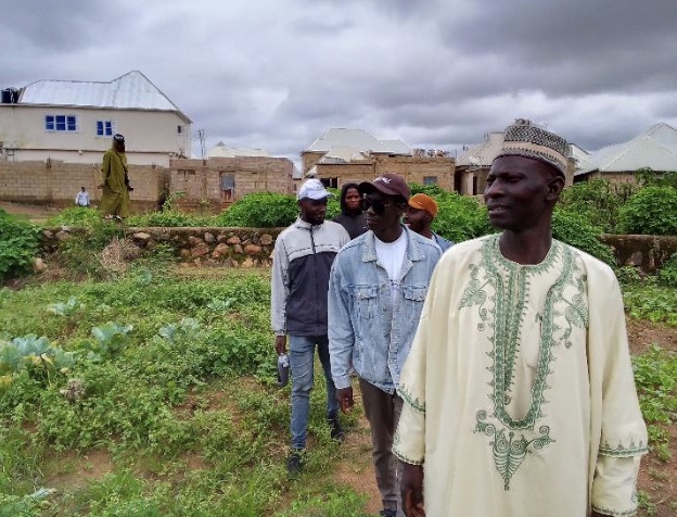

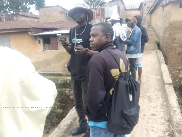

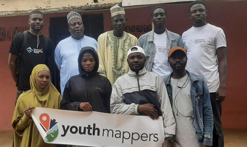
Image 6: YouthMappers with the ward head, Gangare community and his secretary
We aim to identify flood points and map out amenities like schools, health facilities, water points and public toilets within our area of Interest. To do this, we use the flood reporting tool developed by GRMI to collect data on flood points. We also developed a form using Kobotoolbox to collect spatial and attribute data such as building characteristics, capacity of amenities, and potential to be used as a temporary shelter for flood victims. This data will be used in further analysis using GIS techniques and the result will be shared with relevant stakeholders to aid disaster response planning and further inform adaptation and mitigation policies.
Result

Three projects were created in the HOT tasking manager, to map Gangare, Jos Jarawa and Lamingo wards in Jos North. The project to map Gangare was completed on the first day, while mapping is still on going on the other two projects. As of the time of writing this report, 9,721 buildings and about 49km of road have been added to OpenStreetMap by contributors.
The flood point data was used to support the development of an ArcGIS Dashboards for flood event location in Nigeria by GRMI.

Conclusion and Recommendations
If we wait for disasters before we act, it's already late. Preparedness is a way of life and must be part of our everyday culture. Mapping of buildings and roads on OpenStreetMap support humanitarian organizations, development partners and other first responders with spatial data for rapid response to disasters and providing relief materials and evacuating victims. OpenStreetMap is a free and open-source geospatial database, and it has grown to become the go-to map for humanitarian organizations. For this reason, every community deserves to be on the map. We can do that by either volunteering to map or making donations to support the Sustainability of the server.
About the Author

I'm a final year undergraduate student of Geography Education, curious about geospatial technology/data, 2023 YouthMappers Leadership Fellow, and currently serving as president University of Jos YouthMappers.