
GREENING GHANA TOGETHER: KNUST YOUTHMAPPERS JOIN GAIN IN CLIMATE AND SANITATION ACTION IN KUMASI, GHANA
- Isaac Kingsley Arthur-Gaisie
- 4 hours ago
- 4 min read
Introduction
Leadership often begins with a question: How can we use what we know to serve the communities around us, and how can we change the community with what we have? When I assumed office as President of the KNUST YouthMappers Chapter (2024–2025), I carried a strong passion for community engagement, environmental sanitation, and climate action. As a geospatial community enthusiast, I believed our work and activities should go beyond mapping and translate into visible impact on the ground.
That belief led to one of the most meaningful collaborations of our chapter's journey: a partnership between KNUST YouthMappers and Green Awareness International (GAIN), an environmental NGO based in Kumasi, Ghana. This collaboration became a living example of how youth, mapping, and environmental action can come together to drive sustainable change.
Building the Collaboration

As a member of Green Awareness International myself, I saw a natural alignment between the mission of GAIN and that of YouthMappers. When I learned about GAIN's upcoming tree planting and climate education outreach in secondary schools and communities, I reached out to the NGO's President, Mr. George Adomako, to propose a collaboration. His response was immediate and enthusiastic. With the idea gaining momentum, I shared the proposal with our Faculty Advisor, Professor Gift Dumedah, and the chapter executives. The support we received was overwhelming. It became clear that our chapter members were eager to be part of something that combined geospatial awareness, environmental sustainability, and community service.
Mobilising students for off-campus activities came with challenges, particularly transportation and funding. However, the spirit of collaboration prevailed. Our chapter executives and faculty advisor, Professor Gift Dumedah, worked together to address these obstacles, while GAIN also provided financial support to ease transportation throughout the series of activities. What could have been a limitation instead became a lesson in collective responsibility and commitment.

Our first major activity with GAIN took place at Prempeh College in Kumasi, where we participated in a tree planting exercise. Together with GAIN, students, and school authorities, we planted multiple tree species, each symbolizing hope, resilience, and a greener future. For many of our chapter members, this was their first hands-on experience connecting environmental data concepts to physical climate action. It was a moment where theory met purpose.
Educating the Next Generation
Beyond planting trees, we recognized that education is the root of sustainability. At Ahwiaa, where a cluster of schools is located, we led an engaging climate education session that empowered young students to understand their role in protecting the environment.
Green Awareness International educated students on:
Climate change and its effects
Greenhouse gas emissions
Sanitation and plastic recycling


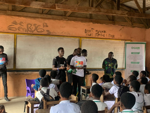
I had the opportunity to introduce the students to YouthMappers and OpenStreetMap, explaining how mapping can support climate action, sanitation planning, and environmental monitoring. The session was highly interactive, with students actively asking questions about what OpenStreetMap is, how data is collected, and how young people like themselves can contribute to mapping their communities. Their curiosity and enthusiasm were evident, as many expressed a strong desire to learn more and be part of future mapping initiatives. This level of engagement was a powerful reminder that when young minds are exposed to geospatial tools early, they can grow into confident changemakers for their communities.
From Classroom to Field: Tree Planting in Action
Following the education sessions, we moved into field activities for tree planting and engaged directly with school heads to understand their environmental challenges. Two key issues stood out:
Poor sanitation infrastructure, including inadequate refuse bins
Free-roaming cattle destroying newly planted trees
Rather than ending the conversation there, we worked with school authorities to identify students living close to the schools who could help monitor and protect the planted trees. This simple yet thoughtful approach fostered local ownership, ensuring the sustainability of the project beyond our visit.
Expanding Impact: The Sofoline Cleanup
Our collaboration with GAIN extended beyond schools. In response to a call by the Ashanti Regional Minister to address environmental sanitation challenges, KNUST YouthMappers joined GAIN for a cleanup exercise at Sofoline, Kumasi. This activity highlighted the direct link between poor sanitation, climate change, and public health, reinforcing the importance of community-driven action in urban spaces.
These collective efforts contributed meaningfully to reducing carbon emissions through tree planting, improving environmental sanitation, and raising climate awareness among young people. Most importantly, the project aligned strongly with the Sustainable Development Goals (SDGs), particularly: SDG 11 (Sustainable Cities and Communities), SDG 13 (Climate Action), and SDG 15 (Life on Land).
Conclusion

This collaboration reminded us that maps are not the final product — impact is. Through partnerships, education, and action, KNUST YouthMappers demonstrated that geospatial communities can lead meaningful environmental change.
From planting trees to empowering students and cleaning public spaces, this journey showed that when youth are trusted, supported, and connected to purpose, they can transform challenges into lasting solutions.
About the Author
Isaac Kingsley Arthur-Gaisie is a Geography graduate of Kwame Nkrumah University of Science and Technology (KNUST), Ghana, and served as President of the KNUST YouthMappers Chapter from 2024 to 2025. He joined YouthMappers in 2021 and has since been actively involved in promoting open mapping, geospatial education, and community-driven projects.
His academic and professional interests lie in GIS, remote sensing, climate action, environmental sustainability, and community engagement. Through his leadership, the KNUST YouthMappers Chapter expanded its outreach beyond campus, collaborating with local organizations to address real-world challenges in climate change, sanitation, agriculture, and sustainable development.


Comments