
Mapping Trees with Brazilian Students to Promote Environmental Awareness and Contribute to Achieving the Sustainable Development Goals
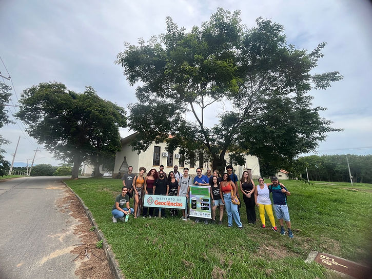
The YouthMappers UFRJ chapter (Rio de Janeiro, Brazil) and the Virtual Institute for Sustainable Development (IVIDES.org) carried out a field mapping of trees on OpenStreetMap on the campus of the Federal Rural University of Rio de Janeiro (UFRRJ), with the support of mobile applications. The MapComplete (https://mapcomplete.org) application was used to record photographs of the individual trees and include data on relevant attributes, such as the circumference of the tree, its species, the Wikidata register, and its geolocation. The activity was led by Raquel Dezidério Souto, president of the YouthMappers UFRJ chapter.
This activity was part of the morning phase of the Green Open Data Day 2025 event, held on March 31, 2025, and organized by the Virtual Institute for Sustainable Development (IVIDES.org), in partnership with the YouthMappers UFRJ, UFRRJ, and UFF Campos chapters. The event was sponsored by TomTom and Wiki Movimento Brasil. In the evening phase, a session was held remotely with guest professors to share the results of their research on topics related to open data and the environmental and socioeconomic dimensions, in order to instill in the audience the relevance of vegetation conservation and help promote related ecosystem services, such as lowering surface temperatures, preserving aquifers, and providing habitat for many species that find a place to roost, feed, and reproduce, among others.

All the archives of the event, including copies of the special keynotes and the video recording, can be found on Wikimedia Commons (https://commons.wikimedia.org/wiki/Category:Green_Open_Data_Day_2025) or on the event's page (https://ivides.org/green-open-data-day). The guide for tagging trees is available on Zenodo.org (https://doi.org/10.5281/zenodo.15121432). You can also find more mapping tips and resources on Raquel's OSM Diary (https://www.openstreetmap.org/user/Raquel%20Dezid%C3%A9rio%20Souto/diary/406429).

Relation to the United Nations Sustainable Development Goals
The event relates to the Sustainable Development Goals (SDGs) 4 (Quality Education), 7 (Affordable and Clean Energy), 11 (Sustainable Cities and Communities), 13 (Climate Action), and 15 (Life on Land).
The Inclusion of Minority Groups and the Educational Nature of the Event
The event's target audience consisted of students and teachers from public universities and other educational institutions in Rio de Janeiro, as well as professionals working in environmental management, urban planning, information science, and cartography. Many of the students at these universities come from economically underprivileged backgrounds and, especially in Rio de Janeiro, are members of so-called minority groups (in terms of representation, not quantity), such as quilombolas, Black and brown people, and residents of the "Baixada Fluminense" (which belongs to the Metropolitan Region of Rio de Janeiro), an area that has historically had worse living conditions and lower human development indicators compared to regions with higher per capita income, such as the more privileged areas of the capital, Rio de Janeiro.
The event is therefore an initiative not only to promote environmental conservation, but also to give these groups access to state-of-the-art methods and techniques in participatory and collaborative mapping, using applications, information systems, and open data, raising awareness of their relevance and usefulness in tackling the consequences of the climate crisis.
Acknowledgements
We would like to thank our partners and sponsors for their support of the event, as well as the participants in both the morning and evening sessions, and the support of the international YouthMappers project.
About the Author
Raquel Dezidério Souto is the president of the YouthMappers UFRJ Chapter (Rio de Janeiro, Brazil) and director of the Virtual Institute for Sustainable Development - IVIDES.org.


Um clube pode impressionar à primeira vista, mas penso que o verdadeiro valor aparece quando você examina os detalhes. Fatores como variedade de jogos, limpeza, profissionalismo da equipe e qualidade geral do ambiente muitas vezes determinam se a experiência é satisfatória. Eu costumo ler avaliações que descrevem visitas reais em vez de focar apenas em informações promocionais. Durante minha busca por clubes no Brasil, o pixbet site oficial surgiu em várias conversas de jogadores sobre locais que valem a pena. Comparar experiências reais fornece uma visão muito mais clara do que confiar apenas em materiais de marketing.
Stickman Hook's minimalist design keeps distractions to a minimum while allowing the exciting gameplay to take center stage.
Space Waves becomes harder the longer you play. The speed increases and obstacles appear more frequently, testing your reaction time and control skills.