
Voyage to 250 OSM Streak Days
- Rabi Shrestha, Kathmandu University
- Nov 4, 2021
- 4 min read
Updated: Nov 8, 2021
The start of something beautiful:
“The journey of thousand miles begins with our first step.” I am from a mapping background, meaning I am an undergraduate student of Geomatics Engineering and my field of expertise are: Geographic Information System(GIS), cartography, photogrammetry, remote sensing, land use policy, land use planning, surveying, cadastre, database management, etc.
For an explorer from a remote village who enrolled in Geomatics Engineering, OpenStreetMap is a great opportunity because I have a passion to work and volunteer for surveying and mapping. Since my early days, I have loved exploring places. And making edits on OpenStreetMap (OSM) is alike what I love and what I feel more passionate about.
MAPPING JOURNEY:
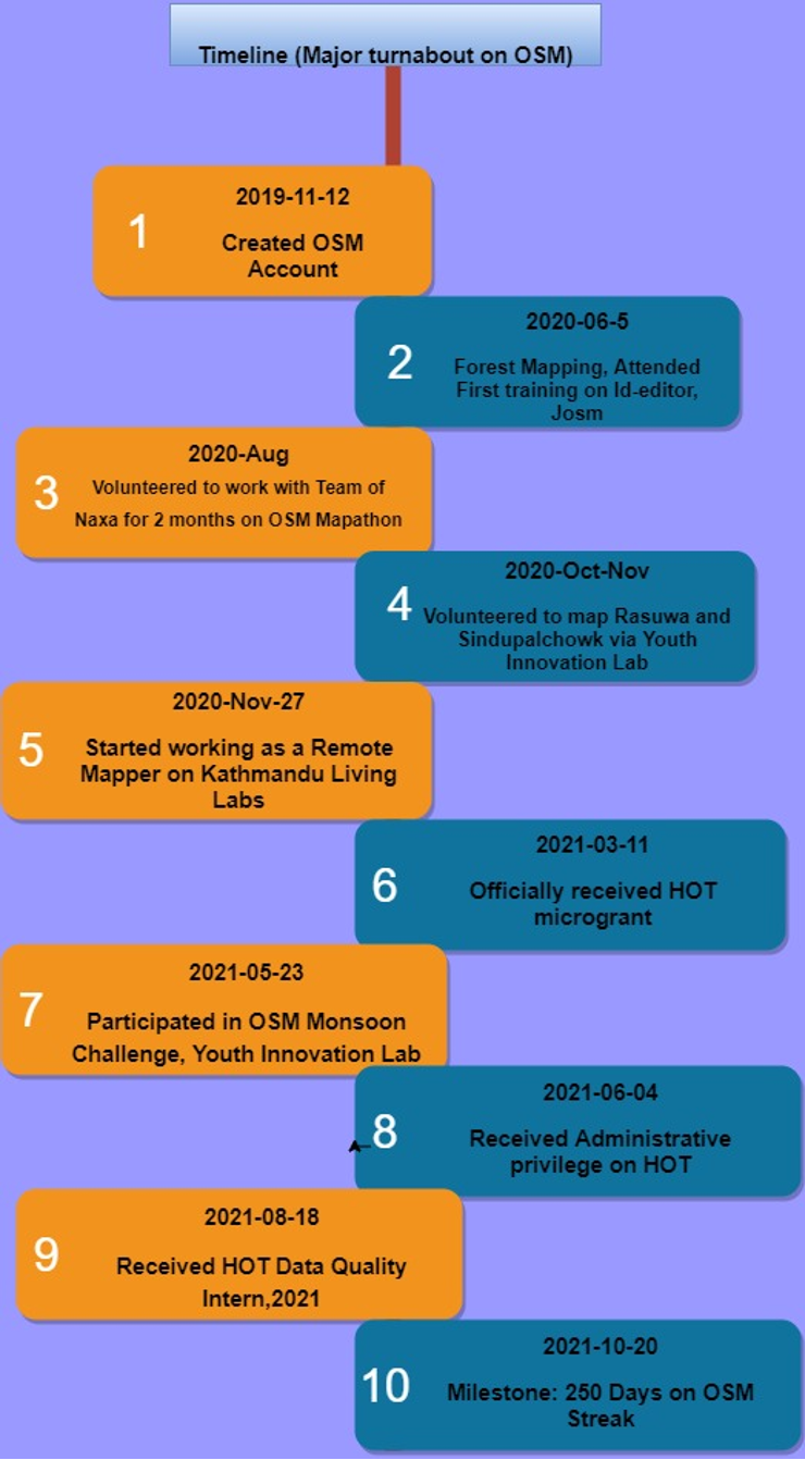
I started my mapping journey in OSM on 12th Nov 2019 with the motive to add my unmapped remote village to the map. So in my early days, I mapped my own locality in OSM. But on the occasion of World Environment Day, in 2020, I participated in an event called “ Forest Mapping” organized by the Geomatics Engineering Students Association of Nepal (GESAN) where I learned editing tools like iD-editor and Java OpenStreetMap (JOSM) and contributed to mapping the forest areas of Nepal. Since then, I have enjoyed mapping better than before. Being a part of this event made me realize that I have a great passion to work and volunteer in surveying and mapping various geographical features and communities around the globe.
And while enjoying my ride on OSM, I got to participate in a month-long mapathon campaign organized by NAXA, where I was responsible for hosting the training and supporting the team involved in overall program management. This campaign was a part of the “Trails and Community Infrastructure Mapping for Emergency Preparedness and Response Project” which focused on mapping the remote parts of Bajhang and Bajura Districts in the far west region of Nepal. This was the turning point on my journey to OSM where I believed my edits are contributing to the needy and I am mapping for a cause.


Similarly, I also participated in mapping Rasuwa and Sindhupalchowk and other different districts and municipalities of Nepal in OSM organized by Youth Innovation Lab (YIL), and I was rewarded as one of the top contributors during the event. Recently, I also volunteered at the OSM Monsoon Mapping Challenge organized by YIL and mapped more than 13,000 buildings. “OSM Monsoon Mapping and Validation Challenge of Dhanusa District” is a collaborative initiative of Youth Innovation Lab (YIL) and YouthMappers for disaster preparedness and response, for instance, monsoons, and I am glad to be one of the participants who can volunteer for a cause.

Besides these volunteering experiences, I also worked as a Remote Mapper in Kathmandu Living Labs (KLL) for a span of about two months. During my time at KLL, I mapped building footprints and road networks of Afghanistan and Bhutan. Contributing to the land of Afghanistan to map buildings footprints were opportunistic and helped me grow in the OSM community. Understanding the typology of Afghanistan via satellite imageries seemed difficult in the beginning. But once I believed I was helping those communities to have them on maps that are visible to the world, I found my soul within their communities, and this has pushed me further to contribute to this field.


Some days I made mistakes, some days I created conflicts, errors and issues while mapping; but the most important thing that I realized is that I learned every day from my mistakes and got handy experience on stabilizing my roots in the OSM community. Mapping the building rooftops rather than building footprints, difficulty in building identification in the dense settlement, mapping entire compounds as buildings were some of the errors I committed while mapping in OSM in the early days. However, with constant guidance and revisions by the team of experts at KLL, I have been able to overcome my mistakes. And these days, I am leading the HOT Community microgrant Impact for “Mapping Chepang communities” of Makwanpur, Nepal. My team from Geomatics Engineering Society (GES) received this microgrant, and as of now, we have already completed mapping and validating Raksirang and Kailash Rural Municipalities. Our team is ready for a field visit and survey once the Covid situation eases.

OSM Streak points collection (http://streak.osmz.ru/)
I strongly believe in the quote, “Supporting other people's success will not delay yours. ” With the thinking from this quote, I have been continuously mapping in OSM and have been involved in guiding other beginner mappers in mapping with the knowledge and skills that I have acquired through my experiences. And with all the skill sets relevant to OSM, I also want to share that I have also been continuing my OSM Streak for more than 250 days and wish to continue more. This means that I have mapped in OSM for continuous 250 days without a break on any day cause I am addicted to mapping communities on OSM. I've mapped a total of 370 days on OSM. During these mapping days, I learned a lot from Humanitarian OpenStreetMap Team (HOT) and YouthMappers trainings. Because of my dedication and all I've learned, I also received a HOT Microgrant and am a HOT Data Quality Intern. I am also a MSF Validator, Validator trainee, UN Mappers member, Geomatics Engineering Society member, and HOT Data Quality Intern. I feel grateful to HOT and YouthMappers for my professional and career development. Looking back at my OSM journey, I would say it has been quite a journey. And lastly, I suggest everyone learn, explore and involve themselves in open data mapping because of its wider applications for a variety of purposes such as humanitarian assistance, disaster management, environmental conservation, and many more.

My total contributions (as of 20th Oct, 2021) are given below:

Timeline (Major turnabout):

About the Author:
Rabi is an undergraduate student of Geomatics Engineering at Kathmandu University, Nepal. He is a person with extreme desire and determination to learn, work and succeed. Currently, he is leading the HOT project entitled "Mapping Chepang community" in Makwanpur which was received as a Facebook community impact Microgrant funded by Humanitarian OpenStreetMap Team (HOT). He is also a HOT Data Quality Intern 2021, a member of YouthMappers (since 2017), an active volunteer at HOT and has also worked as a secretary at Geomatics Engineering Society for the year 2019/20.


Reaching milestones like a 250 OSM streak requires discipline, patience, and heart, and it’s completely valid to balance that responsibility with small moments of rest, where playing Retro Bowl College can become a simple, soothing activity that helps ease cognitive fatigue while still keeping your mind engaged and motivated for the journey ahead.