
YouthMappers and World Bicycle Relief Project: University of Malawi (UNIMA) YouthMappers.
- Davie, Mphatso, Ishmael, Prince, Glory, Lemekezani, Constance & Abdur-rahman- University of Malawi (UNIMA)
- Oct 14, 2022
- 12 min read


DAVIE NTHIYA:
Our chapter, University of Malawi (UNIMA) YouthMappers, was introduced to a very fascinating and yet educative Bicycle for Growth (BFG) project implemented by World Bicycle Relief (WBR) with USAID support in April 2022. The project, now in its early stages in selected developing countries, engaged 10 YouthMappers from our Chapter for 10 days in Zomba, Malawi, in which I participated as a research assistant. BFG Project aims to find solutions to reducing barriers concerning the supply and uptake of low-cost, durable and adjustable bicycles (Buffalo Bikes). It does this by assessing bicycle availability, accessibility and reliability in rural areas. Among other things, bicycle shops, ranks and repair shops, together with paths traded by local people to various destinations, were updated on OpenStreetMaps (OSM) to improve data availability within OSM.
Through this project, I got exposed to one of the most effective tools for addressing development challenges, Participatory Geographic Information Systems (PGIS). Over time, I have perceived GIS to be expert-driven, where a GIS analyst would be responsible for interacting with particular software to produce relevant results (expert-software relationship). It is through this study that I now embrace the potential of PGIS. Unlike ordinary GIS methods, PGIS is multidisciplinary and relies on the integration of “expert” Knowledge with socially and gender-differentiated local knowledge. Participatory methods employ the notion that communities are not homogenous and that local people may not always agree on everything in their locales. Considering this, including local people in addressing challenges they face in their communities is very essential.
One of the most interesting things about the project was meeting with the community participants that were to become our friends in the next couple of days. In our destinations, participants were divided with regard to gender. The division of the members allowed each member to equally contribute, hence allowing a free flow of ideas without any sense of dominance from either gender. It was nice to see the participants organise themselves and start the mapping exercise of their community as they perceived it. The community mapping exercise was followed by a mobility mapping exercise. The participants did all this while pinpointing the things that affect mobility in their communities, for example, seasonal river crossings and obstructions that may affect movement of students, bicycles and people travelling to various destinations. This project made me realise the significance that YouthMappers can bring to their societies as they engage in open discussions with local people. I felt more important since I was finally putting my small skills to productive use.

Another interesting part of this project was that it was an adventure and exploration for me. The project in general allowed me and the chapter members to become more flexible in data collection upon being introduced to fieldwork (Point of Interest (Pol) capture and route data capture) using Kobo for the first time. The knowledge of this tool will allow our chapter to be effective in tackling projects that may require extensive data collection. Individually, I learnt the fundamental concept of working in groups and teamwork. From start to finish, all sides, from the YouthMappers side to the USAID side and finally, the WBR team, worked in coordination, allowing for effective teamwork across all sides. I am very grateful to have been part of what I can call an adventure into Participatory Geographic Information Systems (PGIS). From getting to know people to understanding tools and to riding buffalo bikes into the communities, I had so much fun and can’t wait to introduce these methods to the YouthMappers community.
I urge all YouthMappers out there to keep mapping and participating in these kinds of events when an opportunity comes. I am happy to have been trained by the best and learned a lot from my interactions with Dr Brent McCusker, Rory Nealon and Dr Ryan Avery from USAID and YouthMappers, Ms Gail Jennings and Mrs Aleisha Meyer from WBR. I now have adequate knowledge of YouthMappers and how mapping can contribute to solving issues around us.
MPHATSO BEN:
My participation with the YouthMappers and World Bike Relief (WBR) project was amazing because it exposed me to more geospatial skills, and my skills in interacting with others became so strong. More importantly, we helped the community to find solutions to the problems it had as far as bicycles are concerned by mapping the data we collected for the project.
There are several activities I enjoyed the most in this project. I enjoyed learning new skills of collecting data using the KoboCollect, I was able to collect more data at a short period of time by just using my phone. I also advanced my knowledge on Geo-spatial platforms like OpenStreetMap, Map.me, HOT Tasking Manager through the supervisors we had headed by Dr Brent McCusker. I also enjoyed the participatory GIS, whereby we were able to interact with the community on bike-related issues. I noted that the community is suffering inside and it will only take us the YouthMappers to find solutions our societies are facing using the map skills and technics we have. During this project, I was so excited to know and build strong relationships with some YouthMappers I never knew were part of the chapter.
There is nothing more amazing to me than to be a solution where there is a problem. This project exposed the problems associated with bikes that people are facing, and it was so nice to me as a mapper since I stayed as the bridge to connect the community and their solutions.
I just want to encourage the YouthMappers interested in participating in a similar project, don’t have a second thought. Go for it! I was a person who had little confidence in myself and feared talking to people I did not know. However, when I participated in this project, everything to do with my fear and little confidence changed as I now have strong confidence. I have learnt the skills as far as Participatory GIS (PGIS) is concerned. The project exposed me to several skills like how to collect data and GPS location using the KoboToolbox and export the data collected to OpenStreetMap. I also learnt how best to write the project report since at the end of the project we wrote the reports on we have conducted the survey. I also learnt the skill of interacting with people I have just met for the first time. My favourite experience in the project was when I went to the community and talked to the people about the problems they are facing on the part of bicycles. It was amazing to listen to people themselves and export what we got for the project using KoboCollect to the OpenStreetMap.
ISHMAEL DILIRO:
I am a member of the University of Malawi (UNIMA) YouthMappers chapter, which I joined in the year 2019 following the introduction of YouthMappers worldwide university chapters to us by Ndapile Mkuwu, who is the ambassador for Malawi YouthMappers. Despite pursuing a Bachelor of Science in geography at this university, I personally like mapping with the aim to solve various problems in the community by mapping it. YouthMappers have given me opportunities to participate in various mapping exercises and surveys like monthly mapathons, community mapping, and transect walks.
UNIMA YouthMappers participated in the Bicycle for Growth (BFG) project which happened between April-May,2021 in Zomba, Malawi and I was part of this project as a research assistant. At the end of this project, I gained a lot of experience in how to operate different data collecting tools and techniques on the ground, not just theory, as we learn in class. The first amazing experience is concerning using Participatory GIS (PGIS) which incorporates the community autonomic ideas concerning bike, bike tax and motorbike routes safety and the ability to ride bicycles on those routes due to road conditions. Different community members have different ideas on which routes are dangerous because of their individual perceptions on what is dangerous to them, which is interesting.
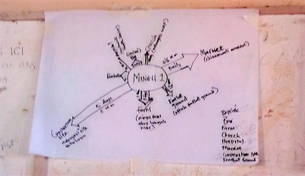
Community mapping exercises at Chichiri Secondary School and Malindi Secondary School opened my mind on the ability of the community to map their own community and trace features that matter to them as far as the use of bikes is concerned. Community members produced sketch maps of their communities on their own and pointed out their challenges which made me learn that involving the community in solving a particular problem they face can bring better solutions rather than planning for them remotely. See the map of where they travel produced by the community below.


In this project, I have also learned how to use KoboToolbox to collect spatial and non-spatial data. KoboCollect which is a mobile phone application is a flexible tool which we used to collect point of interest details based on how the communities like Govala, Matawale, Mpunga and others use bicycle resources around their communities. This was the easiest and probably the best tool I have ever used to collect data, and am happy of being able to know how to use it now. Using this tool, we have learnt that bicycles are widely used in these communities by different groups of people like students, farmers, teachers, health practitioners, businessmen etc.
I have also learned how to upload collected spatial data concerning points of interest and routes of bikes, bike taxis and motorbike taxis around the communities we mapped on OpenStreetMap using the Hot Tasking Manager. I was only conversant with the iD editor technique on the HOT tasking manager but in this project, Rory Nealon introduced us to another validation editor called JOSM, which is interesting to know more of these stuffs.
I encourage all of you who would like to be involved in mapping projects like these because it helps to widen your knowledge of how communities operate on specific cases based on the purpose of your mapping exercise. For example, this project on Bicycles for Growth has helped me to know how communities respond to different challenges they face based on how they use their bicycles. Knowledge is power, and those with skills like in mapping are those needed by the community to solve various mapping problems.
PRINCE MATOPE:
My name is Prince Aaron Time Matope, and I am a member of the University of Malawi (UNIMA) YouthMappers chapter. I joined YouthMappers last year (2021). At first, I didn’t know what YouthMappers do and I always thought that it was only for those in the geography discipline until Ndapile formally presented to us, new members, what YouthMappers is all about. Since then, I have been to different mapathons and engaged in most activities of the chapter because I understood how a single mapping can bring change to the problems in my community. Come this year in April, I was one of the Chanco YouthMappers who were involved in the Bicycle for Growth (BFG) project as a research assistant.
Though I have been to different mapathons, I didn’t know how to map using JOSM. I was only familiar with iD editor. In one of the trainings, Rory Nealon trained us how to map using JOSM. Another thing is about GIS. I have always thought that GIS is special for geography students and it is deep stuff to understand. But during this project, I have learnt how to use QGIS to upload data to OpenStreetMap (OSM) and how crucial it is to use Participatory Geo-Information Systems (PGIS) in projects.
Most of all, I learnt how to use KoboToolbox to develop forms and collect data. This has helped me a lot because now I don’t have to ask my parents for pocket money. I am making money through developing Kobo-forms for those doing projects in their final year.
I urge all of you who would like to involve in a similar project to do so because after the project you will appreciate why mapping of our community is NEEDED for development purposes. You will have a deeper understanding of the needs of the community since you will be engaging with the community directly, and there will be this edge, motivation or fire burning in you to map more.
Before this project, I was that guy who always wanted someone to check his ideas or work if it is perfect for me to present it to the public. Now, I believe in myself, and I can do what I believe is right without asking for someone’s opinion on my work. Adding to that, I was not much of a person who was interactive, but now I am. I even introduced Rory to my favourite drink, lol.
The thing I loved most about this project was when we engaged community members to map the community. The information that was being laid when mapping was fascinating and much. Sometimes you could wonder why such issues are happening in the community, and it motivates you to do more mappings so that the information can be readily available to use when needed. Of course, I can’t rule out riding bicycles when doing transects.
GLORY MWAMUGHUNDA & LEMEKEZAN MTACHI:
World Bicycle Relief (WBR) is a nonprofitable organisation helping pupils and people living in rural areas in terms of mobility by distributing buffalo bicycles to the communities. In April, YouthMappers amalgamated with the WBR members in evaluating the scope of which the bicycles are distributed in the community. We were involved in transect walks around the communities to find paths the community members use more often. Inclusive to that, we mapped out bicycle ranks, bicycle repair shops and bicycle spare part shops.
This activity was exciting since it we learned new set of skills, and it also provided us time to know well my fellow YouthMappers because we had spent much more time together than during the club meetings. We also had fun in the communities where we had to interact with the community members to help us in creating mobility maps and guide us through the transect walk. It was very nice exploring Zomba by biking around our areas of study.

The project taught us different skills such as the use of the KoBoToolbox app and Maps.me as simple software used in adding features on OpenStreetMaps. I learned that an area which is not mapped is not noticeable as such, it is hard for development to take place in that area as the problems are not disclosed.
I would like to motivate my fellow YouthMappers to participate in such projects because one is able to gain new set of skills. It also helps participants to think through the sets of skills on how they can be used in order to bring sustainable projects or activities that can be of importance to their communities.
Participation with the local people was fun as everyone got involved in creating mobility maps of the places they go frequently on plain paper. One crazy experience we had was when we got lost on our way to Malindi Secondary School, this taught us how important to frequently update maps by adding all new features to the map will help us to easily read the map.
CONSTANCE MANGANI:
I was one of the research assistants who participated in the World Bike Relief (WBR) project in April 2022 in Zomba. I was collecting data concerning the mobility of people and how they use their bikes in the community.
I really enjoyed the project especially during the time I was interacting with the community, it was my first time to use KoboCollet when collecting data so the method was easier and quick because of that. And also, the services they gave us, like accommodation, were amazing, and buffalo bicycles they gave us for transportation during the research. And I got new friends like Nelly, Priscilla, Davie, Abdur-Rahman and Prince, who are also members of YouthMappers.
I would like to encourage those who are interested in participating in the same project to do so when they get the opportunity because they are going to learn a lot from it and also improve their skills and knowledge.
In this project, I have learned how to use KoboCollet when collecting data, and how I can interact with people in different societies, especially during the questioning time. Initially, it was really hard for me to know what kind of questions to ask the community to get the proper information, but now I have learned something better. Being able to do research and come up with final and concrete data without a mistake is the best experience for me.
ABDUR-RAHMAN LIWANDA
Hello my name is Abdur-Rahman Liwanda who was at the time during the project in my third year at the University of Malawi, majoring in Bachelor of Science in Geography. I am currently the vice president of the University of Malawi (UNIMA) YouthMappers chapter. In April 2022 we (YouthMappers) as a chapter were introduced to a project that was jointly coordinated by the World Bicycle Relief (WBR), us (YouthMappers) and finally, the United States Agency for International Development (USAID). The USAID team comprised of Dr Brent McCusker, Rory and Dr Ryan whilst the WBR team comprised of Gail, Alisha and Chinsinsi. Ten members from the chapter were selected to participate as research assistants in this project, and I happened to be one of them. Thank God! The project was aimed at finding out where bicycle parts are found within specific parts of Zomba (a city in Malawi), bicycle taxi ranks and bicycle repair places. The primary focus was on the Buffalo bicycle model’s availability. As we progressed through the project, I had a chance to meet new people from both the USAID team, the WBR team as well as community members we had a chance of interacting with and in all honesty, it was super cool. I also had a chance of learning particular aspects of reality for example, I learnt how teamwork is an effective tool in achieving set goals and finally, I learnt on the usage of particular technologies, one of which was KoboCollect, a data collection tool which essentially made our data collection journey through the project super easy. In conclusion, this project coordinated by the three members (USAID, WBR and YouthMappers) allowed me to gain a new understanding of the bicycle world and people’s views towards bicycle usage and how all these fit in with geography.
About the Authors:

Davie Nthiya
Major: Geography
University level: Fourth year
Institution: University of Malawi (UNIMA)
Chapter: University of Malawi (UNIMA) YouthMappers
City residence: Blantyre, Malawi
Hobby/interest outside mapping: Music and reading

Mphatso Ben
University level: Third year
Institution: University of Malawi (UNIMA)
Chapter: University of Malawi (UNIMA) YouthMappers
City and country of residence: Zomba, Malawi
Hobby outside mapping: Attending religious occasions.

Ishmael kelias Diliro
Institution: University of Malawi (UNIMA)
Chapter: University of Malawi (UNIMA) YouthMappers
Ntchewu district: Malawi
Program of study: Bachelor of Science in geography
University of Malawi
Hobby: Music

Prince Aaron Time Matope
Major: Biological Sciences
Year of study: Second year
Chapter: University of Malawi (UNIMA) chapter
District of residence: Nkhota-kota, Malawi
Hobby: I love reading

Glory Mwamughunda
University level: Third-year student
Institution and chapter name: University of Malawi (UNIMA)
City and country of residence: Zomba Malawi
Hobby: Reading and Listening to music

Lemekezani Mtachi
University level: Third year
Institution: University of Malawi
City and country of residence: Zomba Malawi
Hobby: Exploring, Music & Business

Constance Mangani
Major: Bachelor of science in geography
University level: Third year
Institution and chapter name: University of Malawi (UNIMA) YouthMappers Chapter
City and Country of residence: Mulanje, Malawi
Hobby: Drawing and Watching movies

Abdur-rahman Liwanda
Major: Geography
University level: Fourth year
Institution: University of Malawi (UNIMA)
Chapter: University of Malawi (UNIMA) YouthMappers
City and country of residence Blantyre, Malawi
Hobby/interest outside mapping: Android app development (programming)


A Super Work, Super Experience!