
Mapping Our Community: Vassar College’s Hudson Valley Mappers’ Inaugural Event
- Adele Birkenes, Mariah Caballero, Vassar College
- Jan 23, 2019
- 4 min read
Updated: Jan 3, 2021

On Wednesday, 14 November 2018, Vassar College students, local high school students, City of Poughkeepsie officials, and community members gathered to map empty tree pits in downtown Poughkeepsie. In one hour, six teams mapped 81 tree pits and lawns. They then reconvened at the Poughkeepsie Underwear Factory for a catered dinner and discussions on community mapping and the importance of urban trees. Adele Birkenes and Mariah Caballero, co-founders of Hudson Valley Mappers, give a behind-the-scenes look at their process of planning the chapter’s inaugural community mapping event.
Adele: At the beginning of the fall semester, two members of the City of Poughkeepsie’s planning team gave my Environmental Land Use seminar a walking tour of downtown Poughkeepsie. During our walk, Senior Planner Natalie Quinn mentioned that the City was planning to plant trees in 2019 but didn’t have an up-to-date, accurate map of empty tree pits. The most recent street tree inventory – which did include empty tree pits – had been completed in 2006.

It was perfect timing. Mariah and I had just officially launched Vassar’s YouthMappers chapter – known as the Hudson Valley Mappers – as a joint venture between the Department of Earth Science and Geography and the Office of Community-Engaged Learning. We had been searching for a local geospatial data collection project that our chapter could work on during the fall semester. Mariah: After learning about the need for a map of the City’s tree pits, Adele and I applied for funding from Vassar’s Engaged Pluralism Initiative (EPI), an initiative that aims to promote belonging, equity, and conversation among Vassar students and the wider Poughkeepsie community. The generous grant made available to our newly-formed chapter was critical as we began planning our event, and it enabled us to rent out the renovated Poughkeepsie Underwear Factory’s Community Hub for the afternoon. As we planned the event, I visited with Natalie at the Poughkeepsie City Hall. We chatted about the data she wanted to have collected and looked over the existing data from 2006. I was able to meet with Poughkeepsie’s Shade Tree Commission as well and got their input on the types of data they suggested we collect. It was really exciting to see the interest in promoting our community’s urban landscape, and it made me even more excited to plan our event!
Adele: Mariah and I worked with part-time Geography professor and faculty advisor of the Hudson Valley Mappers, Neil Curri, to design a survey that we could use to collect tree pit data in the field. We used the ArcGIS Online mobile application Survey123. I also visited the Poughkeepsie High School, where I led an interactive mapping exercise for students and invited them to Mapping Our Community.
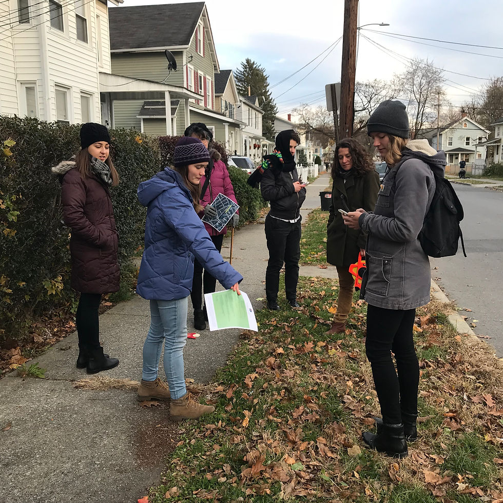
Mariah: Our event kicked off at the Poughkeepsie Underwear Factory on Wednesday, November 14th (International GIS Day!). Adele and I welcomed guests, and both Natalie and Poughkeepsie’s Shade Tree Commission members spoke about the importance of trees in our community. Neil led an introduction to surveying using Survey123. Participants were then divided into teams of three and given maps of the surrounding neighborhoods; they measured, photographed, and reported the empty tree pits on their routes. After an hour of data collection, teams returned to the Community Hub to debrief while sharing a catered dinner. The event closed with talks from Jen Rubbo, Manager of The Environmental Cooperative at the Vassar Barns, and India Futterman, a senior Earth Science major at Vassar who has worked on mapping Poughkeepsie’s ash trees and the invasion of the Emerald Ash Borer.

Professor Neil Curri walking participants through using Survey123 to map tree pits and lawns. Photo credit: Thomas Tomikawa
Participants observing characteristics of a tree lawn and recording them in the survey. Photo credit: Thomas Tomikawa

Tree pits and lawns mapped during Mapping Our Community. Routes are marked in red. Cartography by Adele Birkenes
Adele: Since Mapping Our Community, our team has met with Natalie to share the data that we collected. We are glad that the information will be of use in their tree planting initiative, which will likely begin in late spring/summer 2019. Our chapter plans to continue to engage in community mapping projects to support needs identified by the City of Poughkeepsie’s planning team, as well as by local nonprofits, in the spring semester. Adele and Mariah: We are grateful to the people who helped us make Mapping Our Community a success – especially Phoebe Murray ’21 (Hudson Valley Mappers Publicity Manager), Lisa Kaul (Director of the Office of Community-Engaged Learning [OCEL]), and Neil Curri. We are also thankful to the Vassar Engaged Pluralism Initiative for providing funding for Mapping Our Community and to the OCEL, the Department of Earth Science and Geography, the Vassar College Urban Education Initiative, and The Environmental Cooperative at the Vassar Barns for co-sponsoring the event. Finally, we are grateful to Natalie Quinn for her support in planning the event.
We would love to share tips from our experience designing a survey and mapping in the field using Survey123 with other YouthMappers chapters. If you are interested in undertaking a similar community mapping project, please contact us at abirkenes@vassar.edu and macaballero@vassar.edu.
Adele Birkenes is a junior at Vassar College majoring in Geography and minoring in Biology and Hispanic Studies. This past summer, she interned at the US Agency for International Development (USAID) GeoCenter, where she heard about YouthMappers and decided to start a chapter at Vassar. She is now the President and co-founder of Hudson Valley Mappers. Mariah Caballero is a senior at Vassar majoring in Biology and Geography. She is interested in environmental health, spatial epidemiology, and exposure analysis. She serves as the Vice President and co-founder of HVM.


Comments