
Mapeando un Paraíso Escondido en Pandemia/Mapping a Hidden Paradise During a Pandemic
- Mariela Centeno, YouthMappers Regional Ambassador
- Apr 8, 2021
- 11 min read
English translation below.
Lloa es la parroquia rural más extensa del Distrito Metropolitano de Quito- Ecuador, es un lugar que disfruta de paisajes hermosos, atractivos naturales, lugares turísticos y ecológicos, áreas de recreación y descanso que ofrecen a los turistas nacionales y extranjeros una estadía placentera e inolvidable. Lloa se desarrolla en medio de una gran variedad de pisos climáticos andinos, a pesar de su gran atractivo turístico la parroquia por su geografía tiene poco acceso e información de calidad y gratuita.
En vista de ser aportantes para el desarrollo comunitario de información GeoMap ESPE -YouthMappers se planteó el objetivo de ayudar a la comunidad local con información de datos abiertos presentados en OSM y de esta manera hacer conocer a las personas no solo del Ecuador sino el mundo el gran potencial turístico de la parroquia.
Siendo la plataforma OSM una plataforma de uso y acceso libre y gratuito la información recolectada será de gran ayuda para moradores de la zona, miembros de la comunidad, dirigentes parroquiales, ciudadanos ecuatorianos y personas extranjeras las cuales obtendrán información relevante para su desarrollo.
Con estos antecedentes GeoMap-ESPE empezó la gran aventura a la cual llamamos “Mapeando un Paraíso Escondido”, se realizó un análisis contrario al habitual, donde nos preguntamos ¿Porque no visitar primero los lugares y después presentarlos en la plataforma?, era una idea algo inusual pues el motivo de pandemia era un factor limitante para nosotros como estudiantes sin embargo las ganas de ayudar a esta comunidad fueron aumentando y logramos llegar a tener un acercamiento con el gobierno local.

En la imagen Mariela Centeno Embajadora y miembro de GeoMap-ESPE presentando la iniciativa al gobierno local de la parroquia/ Regional Ambassador and GeoMap-ESPE member Mariela Centeno presents the initiative to the parish’s local government
Se convierte esta idea en un objetivo a ser alcanzado, es así que la experiencia más bonita fue cuando la comunidad nos apoyó y estuvo de acuerdo en “Abrirnos las puertas de su hogar”. La parroquia es magnífica con gente cálida que depende en su gran mayoría, del ingreso económico basado en el turismo nacional y extranjero, de esta manera nuestra segunda interrogante se manifiesta ¿Por qué no ayudar con un levantamiento de datos turísticos donde se pueda verificar características propias de la zona?, se llega al conceso con el GAD parroquial de LLOA , y CONAGOPARE PICHINCHA la cual es una entidad gubernamental que vela por los gobiernos rurales de la parroquia de Pichincha , siendo un ente que trabaja por el bienestar de la comunidad nos extendieron la mano y la propuesta llego a tener la aceptación total.
GeoMap-ESPE se puso en acción, al ser uno de los capítulos pioneros en Ecuador para la red global YouthMappers, el miedo de enfrentar los hechos de tomar información, de capacitarse y sobretodo de llegar a la comunidad existieron, al ser un grupo bastante capaz y siguiendo el lema de YouthMappers “No solo creamos mapas, sino formamos mapeadores”, los miembros motivados con el espíritu de liderazgo emprendimos este proyecto.
Empezamos con una capacitación con ayuda de la Universidad de las Fuerzas Armadas-ESPE, carrera de Ingeniería Geográfica y del Medio Ambiente e Ingeniería en Tecnologías Geoespaciales desarrollando de esta manera el webinar denominado CAPACITACIÓN EN OSM Y GPS NAVEGADOR, en la cual se presentaron expositores muy capacitados que ayudaron no solo al grupo sino a la comunidad universitaria a conocer el uso de estas herramientas las cuales son útiles para el levantamiento de información.


En las imágenes asistentes al webinnar y expositores del evento realizado/ Webinar assistances and event exhibitiors
Con la capacitación hecha GeoMap, se organizó para realizar el reconocimiento del lugar donde se acudió a realizar el levantamiento de información este reconocimiento fue verificado en la plataforma OSM.

En la imagen Lloa sector para la toma de información/ Lloa sector for the collection information
Al ser paraísos ocultos en la naturaleza el equipo se preparó para un trabajo de campo en pandemia que nos tomó aproximadamente dos días, al ser lugares un poco complejos para acceder se realizó el levantamiento creando grupos de trabajo y verificando la presencia de zonas turísticas, visitándolas, recorriéndolas y preguntado a moradores de la zona o a sus propios dueños.
El trabajo no solo sería el reconocimiento de estas áreas turísticas, también para contribuir a la comunidad el GAD parroquial solicito al equipo la ayuda para levantar información de las condiciones en las que se encontraban estos sectores, su accesibilidad a servicios básicos entre estos la accesibilidad a internet y a su vez verificar la productividad que tiene el sector.
De esta manera el reto llego, el fin de semana sábado y domingo 30 y 31 de enero del 2021 el equipo cumpliendo en su gran mayoría protocolos de bioseguridad se acercó a la comunidad ayudados de GPS, hojas de campo y la capacitación pertinente, se procedió al levantamiento de información.


En la imagen 1 grupo GeoMap ESPE- YouthMappers en la parroquia Lloa listos para realizar el levantamiento de información y en la imagen 2 Daniel Moreno y Karla Meza tomando información con la ayuda de encuestas/ Image 1 group of the GeoMap ESPE- YouthMappers in the Lloa parish ready to carry out the data collection and in image 2 Daniel Moreno and Karla Meza record information for the surveys
El equipo tuvo contacto directo con la comunidad encuestando y levantando información GPS para su posterior procesamiento, para el recorrido compañeros conversaron con los pobladores del lugar contándoles del proyecto del objetivo que se llevaría a cabo teniendo una apertura realmente favorable, la comunidad de Lloa estuvieron siempre prestos a colaborar.

En la imagen Veronica Cachipuendo y Carolina Garcia miembros de GeoMap-ESPE acompañadas de Fernanda Quinaluisa miembro de Conagopare Pichincha con un morador de la zona/ Veronica Cachipuendo and Carolina Garcia members of GeoMap-ESPE accompanied by Fernanda Quinaluisa member of Conagopare Pichincha with a resident from the area
La aplicación de encuestas y levantamiento de fichas de campo, así como la toma de puntos GPS fue personalizada y cumpliendo las medidas óptimas para tomar la información más verídica que ayude a un procesamiento adecuado.

En la imagen Gonzalo Araujo, Carla Meza, Andy Lema, Mishell Catucuamba miembros de GeoMap-ESPE socializando el proyecto con moradores de la zona/ Gonzalo Araujo, Carla Meza, Andy Lema, Mishell Catucuamba members of GeoMap-ESPE introducing the project to residents in the area


En la imagen Gonzalo Araujo y Stephany Garcia miembros de GeoMap-ESPE levantando información para el proyecto con moradores de la zona/ Gonzalo Araujo and Stephany Garcia members of GeoMap-ESPE documenting information for the project with locals
El domingo 31 de enero del 2021 a horas de la tarde se terminó el levantamiento de información, al ser Lloa una parroquia pequeña no se tuvo mayores complicaciones teniendo la acogida necesaria y cumpliendo con todo lo especulado en normas de bioseguridad, sin ninguna novedad.

En la imagen grupo GeoMap ESPE- YouthMappers en la parroquia Lloa finalizando el levantamiento de campo de información/ GeoMap ESPE- YouthMappers group in the Lloa parish finishing the survey of the field information
El mes de febrero se escanean los datos, se tabulan encuestas, se procesa información descargando datos GPS para su posterior publicación en la plataforma OSM.
Finalmente se coordina con el Gobierno Parroquial, Universidad y Estudiantes para la presentación de datos y el trabajo realizado, fue de gran ayuda también la información tomada para la creación de mapas de la zona donde se representa factores muy interesantes que suceden en Lloa.


En la imagen 1 Nicol Proaño miembro de GeoMap-ESPE trabajando en la descarga de datos obteenidos en el trabajo de campo y en la imagen 2 Stephany Garcia miembros de GeoMap-ESPE trabajando en OSM/ Picture 1 Nicol Proaño member of GeoMap-ESPE is working on downloading the data obtained during the field work and picture 2 Sephany Garcia member of GeoMap-ESPE working in OSM
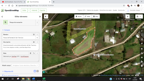
Como parte de la edición tenemos una contribución importante como se muestra el Mapa 1 muestra las actividades económicas que tiene la parroquia a más de ser zona turística, los moradores consideran que netamente trabajan en el campo es decir agricultura, ganadería y áreas relacionadas, mientras que en el Mapa 2 se muestra el grado de conectividad de internet que tiene la parroquia.

MAPA 1: Actividad económica de la parroquia Lloa/MAP 1: Economic Activity in the Lloa Parrish

MAPA 2: Conectividad de internet en la Parroquia Lloa/MAP 2: Internet Connectivity in the Lloa Parrish Region
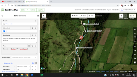
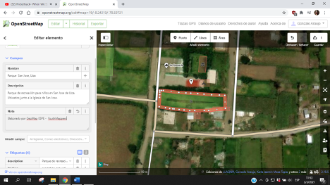
Como presentación de resultados tenemos también el aporte de áreas turísticas con las características correspondientes del levantamiento, lugares los cuales se puede localizar gracias a que la validación de GeoMap fue hecha, lugares como los mostrados a continuación y muchos más son el aporte valioso que se deja a este pequeño paraíso.


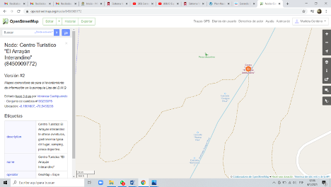
En las imagen grupo GeoMap ESPE- YouthMappers en El Centro Turístico Arrayan Interandino de la parroquia Lloa y su ubicación en la plataforma OSM/ GeoMap ESPE- YouthMappers group in the Arrayan Interandino Tourist Center of the Lloa parish and its location on the OSM platform


En las imagenes cascadas del Guagua Pichincha de la parroquia Lloa barrio San José y su ubicación en la plataforma OSM/ Waterfalls of Guagua Pichincha of the Lloa parish neighborhood, San José, and its location on the OSM platform


En las imagenes grupo GeoMap ESPE- YouthMappers en Cruz Loma de la parroquia Lloa y su ubicación en la plataforma OSM/ GeoMap ESPE- YouthMappers group in Cruz Loma of the Lloa parish and its location on the OSM platform


En las imagenes colaboración GeoMap ESPE- YouthMappers en la plataforma OSM de la parroquia Lloa/GeoMap ESPE- YouthMappers collaborations on the OSM platform of the Lloa parish
Finalmente, de esta grata experiencia el equipo se lleva recuerdos preciados y la experiencia grata de ayudar a la comunidad donde se obtuvieron más de 50 puntos de carácter turístico en la parroquia Lloa, se tabularon más de 180 encuestas realizadas a los moradores de la Parroquia, se levantó información relevante como canchas, iglesias, centros de salud y algunos lugares de productividad los cuales no constaban en la plataforma.
Como mapeadores recomendamos que los estudiantes se interesen por zonas rurales para que en un proceso post pandemia se ayude a la reactivación de actividades turísticas favoreciendo a la economía y desarrollo de lugares como este.
Este proyecto no se podría haber llevado acabo sin el equipo de estudiantes los cuales son pioneros en el Ecuador con el primer capítulo de YouthMappers los cuales seguirán trabajando para el liderazgo y desarrollo de la comunidad creando información de datos abiertos que servirán para el desarrollo no solo del país sino del mundo entero.
GeoMap ESPE -YouthMappers va siempre a paso firme con nuestro lema TODO LO PUEDES MAPEAR.
Mapping a Hidden Paradise During a Pandemic
Lloa, the largest rural parish in the Metropolitan District of Quito, Ecuador, it is a place that enjoys beautiful landscapes, attractive nature, tourist and ecological attractions, and recreational areas that offer tourists a pleasant stay. Lloa is located in the middle of a variety of Andean climates, and its geography allows the parish little access to free and quality information, despite the large tourist population.
As contributors in the developments of community information, GeoMap ESPE-YouthMappers created this project to help transfer information to the local communities through open data in OSM, allowing people of Ecuador and the world to understand the potential of the parish as a tourist attraction.
The OSM platform is both free and easy to access information collected, making it a helpful resource to learn about relevant information for members of the community, parish-goers, Ecuadorian citizens, and international tourists.
With this background knowledge, GeoMap-ESPE started the adventure that we call “Mapping a Hidden Paradise.” We started by doing an analysis where we asked the question, “Why not visit the sites first and then display them on the platform?” It was an odd idea, considering limiting factors of the pandemic for students such as ourselves. Nevertheless, our desire to help the community increased, and we were able to create a relationship with the local government.
This idea became an objective to be reached and the community helped us by “opening the doors of their home” which allowed for a beautiful experience. The parish is filled with citizens who mostly depend on revenue through national and international tourists. It was through this observation that our second research question arose, “Why not help with a clarification of tourist data where we can verify characteristics of specific zones. We reach a consensus with the parish GAD of Lloa and CONAGOPARE PICHINCHA, a government entity that provides assistance to rural governments of the Church of Pichincha. Being an organization that works towards the wellness of the community, they extended their hand and accepted us.
GeoMap-ESPE went into action. As one of the pioneer chapters in Ecuador of the global YouthMappers network the challenges in collecting information, training and getting to the community existed. Being a quite capable group and following the YouthMappers motto, “We don’t just build maps, we build mappers” the members, motivated by the spirit of leadership, undertook this project.
We started with a training with the help of the Universidad de las Fuerzas Armadas-ESPE, a focus in Geographic Engineering and the Environment and Engineering in Geospatial Technology, developing a webinar called TRAINING IN OSM AND GPS NAVIGATION. Where they presented exhibits that not only helped the group, but also the university community to learn useful tools for gathering information.
As they are hidden paradises in nature, the team prepared for fieldwork during the pandemic that took us approximately two days since they were somewhat complex places to access. We executed the survey by creating work groups, visiting possible tourist areas, going through them and asking residents of the area or their own owners to verify a tourist presence.
The work would not only be the recognition of these tourist areas but also to contribute to the community. The GAD parish asked the team to help them gather information on the conditions in which these sectors were found, their accessibility to basic services, including accessibility to the internet and in turn to verify the productivity of the sector.
It was with this work that we were able to finally start our challenge. On January 30 and 31, 2021, the team, mostly complying with biosafety protocols, approached the community with the help of GPS, field sheets and the relevant training. We proceeded to gather information.
The team had direct contact with the community, surveying and collecting GPS information for further processing. For the tour, colleagues talked with the residents of the town, telling them about the objective of the project that would be carried out having favorable benefits. The community of Lloa was always there ready to collaborate.
The application of surveys and field data collection, as well as the recording of GPS points, was personalized and complying with the optimal measures to take the most truthful information to help proper processing.
On Sunday, January 31, 2021, in the afternoon the information gathering was completed. Because Lloa is a small parish, there were no major complications. We had the necessary reception and complied with everything speculated in biosafety regulations without any problems.
In February, the data was scanned, surveys were tabulated, and information was processed by downloading GPS data for later publication on the OSM platform.
Finally, in coordination with the Parish Government, university and students a presentation of the data and the work carried out occurred. The information taken for the creation of maps of the area was also of great help, where very interesting factors that happen in Lloa are represented.
As part of the project, we have an important contribution. As shown in Map 1 (above), the economic activities that the parish has in addition to being a tourist area, the map specifically shows areas that the residents consider work-related such as agriculture, livestock, and similar areas. Map 2 (above) shows the degree of internet connectivity that the parish has.
In addition to the maps with results, we also added tourist areas to OSM with the corresponding characteristics of the survey. Places can be located thanks to the GeoMap validation efforts and places like those pictured above (e.g. Arrayan Interandino Tourist Center, Waterfalls of Guagua Pichincha, Cruz Loma) and many more are valuable contributions to this little paradise.
Finally, from this pleasant experience, the team takes precious memories of helping the community where more than 50 tourist points were obtained in the Lloa parish and more than 180 surveys were tabulated from the residents of the Parish. Relevant information was collected such as fields, churches, health centers and some places of productivity which were not included in the platform.
As mappers, we recommend that students take an interest in rural areas. So that in a post-pandemic process, they help to reactivate tourist activities, favoring the economy and development of places like this.
This project could not have been carried out without the team of students, who are pioneers in Ecuador with the first chapter of YouthMappers, who will continue working for the leadership and development of the community- creating open data information that will serve for development, not only of the country but of the whole world.
GeoMap ESPE -YouthMappers is always at a steady pace with our motto EVERYTHING CAN BE MAPPED.
Gracias a/ Thank you to:
YouthMappers
Gracias a/Thank you to:
Miembros de/Members of GeoMap ESPE -YouthMappers
PhD. Esthela Elizabeth Salazar Proaño (Docente tutor del capítulo)
Nicole Jackeline Proaño Reinoso
Stephany Carolina García Guamangallo
Verónica Elizabeth Cachipuendo Amagua
Daniela Alejandra Moreno Carrillo
Esteban Adrián Aguirre Rosales
Marcelo Alejandro Vásquez Orbe
Deysi Estefania Jaque Intriago
Bladimir Alexander López Hoyos
María Belén Zapata Ramos
Karla Jazmín Meza Tapia
Tamya Sisa Zhingre Tene
Mishell Fernanda Catucuamba Guatemal
Gonzalo Estuardo Araujo Villacis
Ing. Alex David Chuquitarco Taco
Carolina Estefania García Mancero
Andy Ronny Lema Jacho
Miembros de la/Members of the Universidad de las Fuerzas Armadas –ESPE
Ing. Alexander Robayo (Director de la carrera CIGMA-ITGR)
Ing. Eduardo Kirby (Docente colaborador en la capacitación)
Ing. Cesar Leiva (Docente colaborador en la capacitación)
Miembros del/Members of the GAD Parroquial de Lloa
Abg. Enrique Gonzáles (Presidente de la Parroquia)
Sra. Mónica Gálvez
Miembros de/Members of CONAGOPARE PICHINCHA
Srta. Fernanda Quinaluisa
Sr. Danilo Quijos
Miembros de/ Members of CONSEJO PROVINCIAL DE PICHINCHA
Arq. José Luis Gavilánez
Ing. David Castro
Mariela Centeno: Estudiante de la Universidad de las Fuerza Armadas –ESPE Ecuador, está cursando los últimos semestres en la carrera de Ingeniería Geográfica y del Medio Ambiente, Una de las Fundadoras y presidenta del primer capítulo en Ecuador GeoMap ESPE- YouthMappers de la Universidad ESPE embajadora regional para Latinoamérica en Ecuador 2020-2021.


Comments