
Mapping Nepal’s Springs and Ponds on OpenStreetMap: A Study of Seven Municipalities of Kavre, Nepal
- Rabi Shrestha
- Oct 2, 2025
- 6 min read
Over the past weeks, I completed one of my most detailed mapping tasks yet—uploading and verifying more than 5,000 points of spring and pond locations to OpenStreetMap (OSM). This wasn’t just a bulk upload; it was a carefully planned process of data preparation, cleaning, verification, and quality control to ensure every feature was accurate and valuable for the OSM community. A sincere mention to ICIMOD and Srijan Thapa - Research Associate, ICIMOD for leading the field survey to collect these valuable data. The data is readily available at RDS ICIMOD Portal.

This dataset documents a spring shed management initiative led by ICIMOD in seven municipalities of Nepal’s Kavrepalanchok district, addressing water scarcity from drying springs and ponds. Covering 743 km², it maps 5,689 water sources, of which 27% have dried and 58% of active ones show declining flow due to earthquakes, droughts, infrastructure expansion, and other natural hazards. Information includes source location, condition, discharge, usage, socio-economic data, adaptation measures, biophysical traits, and governance factors. Considering the importance and necessity, only major attributes are added in OSM. Using a six-step protocol, 150 trained Community Resource Persons collected data via the Survey123 app. The project highlights the effectiveness of citizen science, gender-inclusive practices, and digital tools for scaling spring shed management across the Hindu Kush Himalaya and similar regions.

From Raw Data to Ready-to-Map

The journey began with a large dataset of springs and ponds about 5689 Point of interest (POI) Data. While the volume was impressive, the raw data needed proper filtration, OSM tags and cleaning before it could be integrated into OSM. I carried out thorough filtration and cleaning, ensuring that every point had correct attributes and location details. This included:
Removing duplicate or irrelevant entries.
Standardizing naming and attribute formats.
Correctly tagging features according to OSM’s tagging conventions.
By the end of this stage, the dataset was structured, consistent, and ready for mapping. Proper OSM Tags were given beforehand in Excel. And many data quality issues were fixed before final uploading.
Software and Plugins Used for Data Visualisation and Upload
To handle and visualize this bulk data efficiently, I relied on Java OpenStreetMap Editor which we call JOSM in general. Few plugins supported the process for further verification, validation, and ensuring all the data are checked individually. I relied on following plugins:
Opendata Plugin – for importing and handling the cleaned dataset within JOSM.
Todolist Plugin—to systematically review and process each feature without missing any point.
Considering the clarity of the image, ESRI World Imagery was used for additional reference for location verification alongside existing OSM data to avoid reupload of the same feature. These tools allowed me to move through the dataset methodically, reviewing each point and its attributes with precision.
General Methodology
Once the cleaned CSV file with all attributes was uploaded, the appropriate projection and parameters were defined to ensure compatibility with the OpenCV plugin during import. After loading, the point data were displayed on the map (as shown in Figure X). To enhance visualization, a basemap layer was added, allowing the spatial distribution of the data to be clearly observed and analyzed in its geographic context. Being a local resident of these areas, it helped me validate the data with more ease.
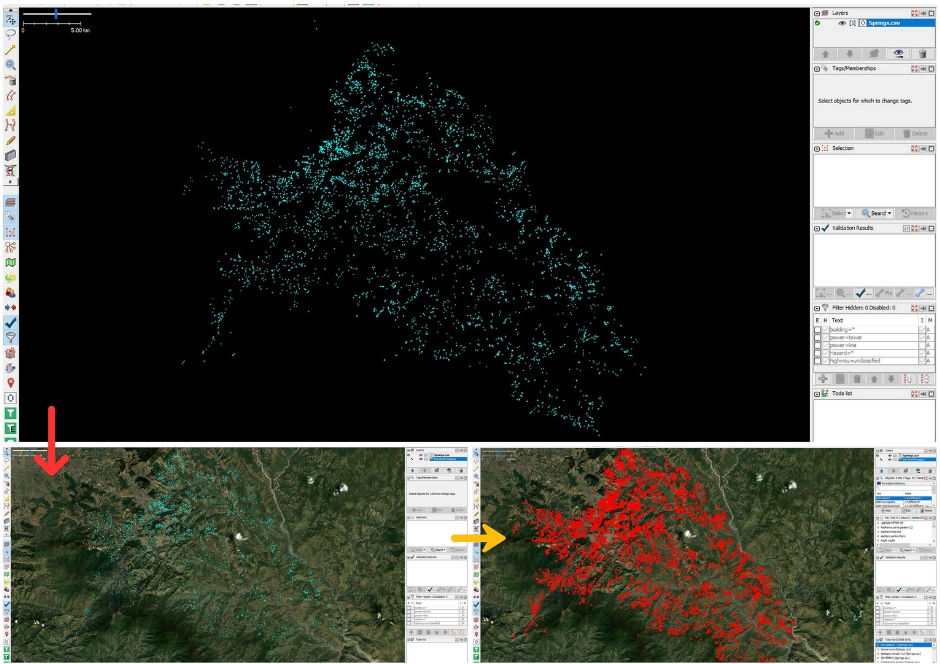
All the mapped points were added to the Todolist plugin list, ensuring that every attribute and its corresponding location could be carefully monitored. During this process, any errors such as duplicate entries, incorrect tagging, or other inconsistencies were identified and corrected. After the individual data checks were completed, a JOSM validation tool was applied to scan the dataset as a whole. This step helped detect additional issues, such as wrong tagging or data duplication (as illustrated in Figure X), which were then systematically resolved to maintain data quality and reliability.
The final data is then uploaded into the OSM database under the Creative Commons Attribution-ShareAlike 2.0 license crediting the ICIMOD on each data.
Quality Validation and DQI Checks
Before the final upload, I ran JOSM’s built-in validation tools to catch common tagging, geometry, or structural issues. Additionally, I reviewed and resolved any OSM Data Quality Initiative (DQI) issues to align with community mapping standards. I used Tagfinder and Taginfo, and not to forget OSM Wiki for specifying suitable tags so such features can be traceable and exported using those standard tags whenever needed.

The Final Upload
After days of review and adjustments, I completed the final step: uploading the 5,000+ points to OpenStreetMap with utmost satisfaction. Every time I contribute something to OSM, it gives me immense pleasure. This is the reason why I have been volunteering in OSM for the last 6 years. Although bulk upload like this is not recommended in OSM, sometimes considering the nature of the data and not disturbing the data quality on OSM, advanced mappers upload data after proper refinement and a good changeset comment.

Data Export from OSM
Each feature now contributes to a richer, more accurate representation of Nepal’s natural water resources, benefiting everyone from local planners to global researchers. All these data are available on RDS Portal of ICIMOD in excel. But whenever people begin data hunting, they keep their eye on the free and open-source platform which is OpenStreetMap (OSM), from which anybody can contribute and extract data from OSM. Besides, one can easily visualise the features with the different basemap Imagery layer in this. This is the sole reason for uploading data there.

To complement the mapping and verification process, I also performed a custom data export from OpenStreetMap using Overpass Turbo. This powerful query tool allowed me to filter and extract only the relevant features—springs and ponds—along with their associated tags and metadata. By tailoring the Overpass query to my needs, anyone could generate a clean, structured dataset in multiple formats (GeoJSON, CSV, KMZ etc.) for further analysis, visualization, and sharing. This ensured that the data I worked with was both up-to-date and directly aligned with the attributes and locations already present on OSM, supporting consistency across mapping and reporting workflows. To those who are expecting to download in multiple formats, this tool can be the better approach. Meanwhile, using QGIS, Planet OSM or RD Portal of ICIMOD also remains a better approach for data download.
Why This Matters
Springs and ponds are vital resources for communities, ecosystems, and climate resilience planning. By making their locations and details openly accessible on OSM, we empower:
Local communities – for water access planning
Researchers – for hydrological and environmental studies
Disaster risk managers – for identifying vulnerable or critical water sources
Crowd Sourced Mapping – for engaging and ensuring local ownership over data
Citizen Science Approach –Public volunteers involving in data collection
This initiation reinforces how open data and collaborative mapping can make a tangible difference. By combining careful preparation, smart tools, and a commitment to quality, we can ensure that every addition to OSM is not just more data — but better data for a better and planned future. I hope initiation like this will contribute to Spring Water Management and inspire further community-driven efforts to safeguard, restore, and sustainably utilize these critical water sources for generations to come.
References
About the Author
Mr. Rabi Shrestha is a Geomatics Engineer/Drone Pilot at NEA Engineering Company Ltd. In the OSM world, he goes by the username frozenrabi where he has been contributing in mapping, validating and empowering people via various trainings/mapathons for the last 6 years. He was a YouthMapper member from 2017-2022 from chapter Geomatics Engineering Society (GES).
In addition, he is also a HOTOSM Micrograntee/Voting Member/Global Validator, Data Quality Intern (2021) and an active member of the OpenStreetMap Foundation and holding an impressive 420-day OSM mapping streak record. Not to forget his contribution to mapping and validation efforts in 67 countries, supporting projects on disaster response, poverty alleviation, and the Sustainable Development Goals. Moreover, he has been volunteering with HOTOSM, UN Mappers, MSF Validators, MapBuds, OSM Nepal and the Geomatics Engineering Society. A couple of months earlier he also led Road Network Validation of Karnali Province in Nepal as a Senior Field Mapping Expert from HOTOSM. He continues to map almost daily, advocating for better geospatial data to drive meaningful local and global impact. For details: https://linktr.ee/frozenrabi


This is such an impressive and meaningful project! Mapping thousands of water sources with such care and precision truly shows how technology and community collaboration can make a real difference in addressing water scarcity. Pokerogue