
COLLABORATIVE MAPPING VOLUNTEERING AT THE SENDA VERDE WILDLIFE SANCTUARY
- Silvana Esther Cachi Zambrana, Alejandra Campos Loayza, Maria Angela Ramirez Rodriguez, and Leonardo Cabrera Espindola
- Sep 19, 2025
- 5 min read
Place: Nor Yungas, Yolosa, Bolivia – Senda Verde Animal Shelter

Senda Verde is a refuge dedicated to the rehabilitation and protection of wildlife in the Amazon rainforest of Bolivia. Unlike a conventional tourist destination, its main mission is to provide care and rehabilitation to rescued animals, many of which have been victims of illegal wildlife trafficking, mistreatment in captivity, or have been affected by the burning of their habitats. Although it welcomes visitors to support its operations, educate, and raise awareness about conservation, Senda Verde primarily focuses on animal welfare and promoting responsible wildlife practices.
Illegal wildlife trafficking consists of the illicit commercialization of wild species that are stolen from their natural habitats. In Bolivia, alarming cases of illegal wildlife trafficking have begun to occupy a prominent place on the media agenda.
Senda Verde Wildlife Sanctuary is a charity dedicated to improving the lives of rescued native Bolivian wildlife by providing medical care, food, and housing. Their mission is to save and protect rescued wild animals from cruelty and suffering, as well as to inspire people to care for wildlife.
Our main objective upon receiving the invitation to carry out a mapping volunteer activity, as a chapter, was to prepare the information of the base map of the territorial structure for each animal habitat, with the purpose that this information serves for more detailed planning in the future.
Immersion in Nature: Discovering Senda Verde

Upon arriving at the Senda Verde refuge, we were warmly greeted by Vicky Ossio and Marcelo Levy, the founders of this wonderful wildlife sanctuary. From the first moment, Vicky and Marcelo's passion and dedication were evident, creating an environment of collaboration.

We presented our work proposal as YouthMappers, detailing our skills and how we planned to apply our mapping and data collection techniques for the benefit of the shelter. In turn, they shared their specific expectations and needs, helping us align our objectives to ensure a positive and meaningful impact.
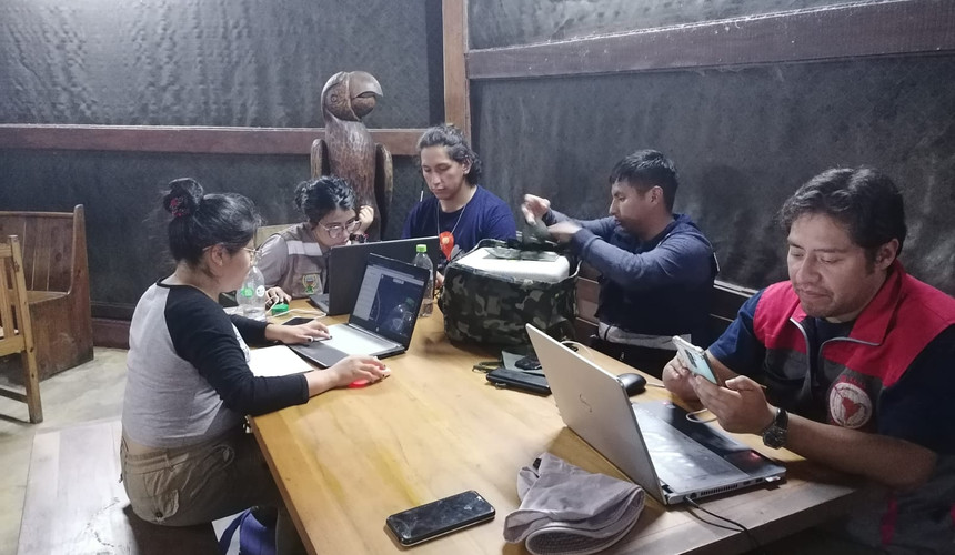
The first day focused on planning and organization. With the guidance of Vicky and Marcelo, we prepared for the intense field day that awaited us. Our team set out to update the refuge data using the appropriate applications and software for mapping in Senda Verde.
The collaboration with the founders of the shelter and the opportunity to apply our knowledge in a real context filled us with enthusiasm for the days to come.
Exploring and Collecting Data
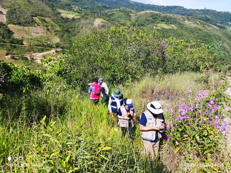
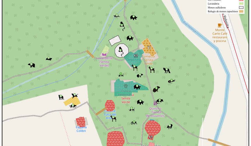
On our second day at Senda Verde, Vicky Ossio, along with the refuge's volunteer team, took us on an in-depth tour of the sanctuary, exploring every corner and revealing the stories of this wildlife sanctuary. We took this opportunity to collect detailed information on the dispersal of animals, using the application StreetComplete for taking precise notes, marking trails, and capturing street view images with Mapillary.

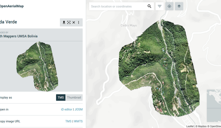
In the afternoon, we carried out the first drone flight, which allowed us to obtain impressive aerial views and valuable data. In the evening, we met to verify and complement the information collected, working closely with the tour manager to ensure the accuracy and integrity of our data.
The next day, we dedicated ourselves to final data collection and carried out one last drone flight, aimed at correcting small inaccuracies in the previous delineation. This effort culminated our fieldwork, leaving us with a sense of accomplishment and significant contribution.


Native Bees of Bolivia: A Song to Life in Danger

Native bees, vital to the health of our ecosystems, are disappearing at an alarming rate, victims of human action and environmental imbalance.

During our visit, we were able to see that, in addition to being a refuge for wild animals, Senda Verde is dedicated to saving pollinators. They are creating rewilding spaces, sowing the seeds of the future where the song of native bees once again resonates in harmony with nature.

Senda Verde, a nonprofit organization based in Bolivia, fights to protect the Amazon. Through a reforestation and protection initiative in a strategic biodiversity corridor, reforestation supports communities to confront the climate emergency and the extinction crisis. The Senda Verde sanctuary serves as a refuge for native fauna and flora, providing them with a safe space to thrive.
We collected and georeferenced small details, as well as the incredible work they do in the butterfly garden. By joining Senda Verde, we can contribute to the restoration of the Amazon and ensure a sustainable future for generations to come.
Data Processing
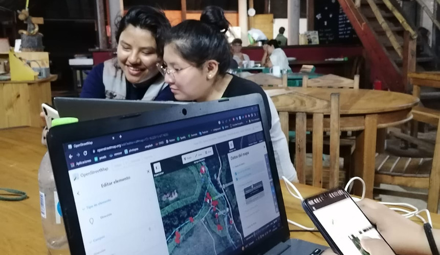
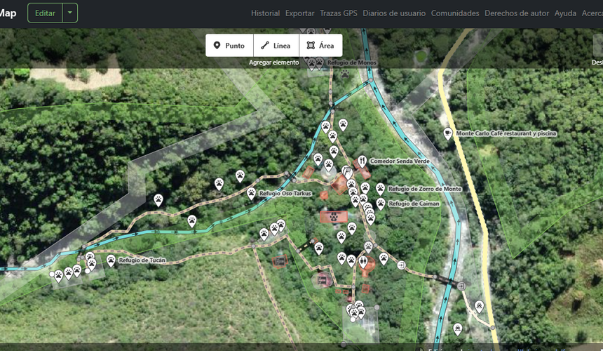
With all the data collected, POIs generated, and with the complements provided by the refuge volunteers, mapping was done with different platforms and using the drone flight mosaic as a base for greater detail. Some of the data includes parking, food places, schedule availability, the distribution of animals, and the delimitation of the place. All of these are available on OpenStreetMap.


Conclusion
Our experience as YouthMappers UMSA volunteers at the Senda Verde shelter in Coroico, Bolivia, has been transformative. We deeply appreciate the invaluable support of all the volunteers who accompanied us during data collection. Visiting the Senda Verde shelter opened our eyes to the extraordinary work carried out by Vicky Ossio, her husband, and their entire team of volunteers. The effort and dedication they put into the care and well-being of rescued animals is an inspiring example of social commitment.
Witnessing the different stories of the animals that have arrived at the shelter moved us deeply. Each of them has suffered the consequences of illegal wildlife trafficking, a reality that forces us to reflect on the need to protect biodiversity and combat this crime. Through our mapping work, we contributed to georeferencing the refuge and making its important work visible.
We hope that this effort will serve to attract more support and resources for this noble cause. We feel motivated to continue supporting volunteers and the community in general in the search for a better future for wild animals. We are deeply grateful for the opportunity to have been part of this project and to have learned so much about wildlife conservation.
To learn more about the refuge: Senda Verde Page: https://www.sendaverde.org/es/
About the Authors
María Ángela Ramírez Rodríguez is a graduate of the UMSA Geographic Engineering program, with experience in the management of geospatial data and thematic cartography. Currently, she works as a teaching assistant for the subject of “Population Geography” and is an active member of YouthMappers UMSA Bolivia, leading the management of advertising and data processing for community projects.
Alejandra Campos Loayza is a graduate of the Geographic Engineering program. Currently, she works as a teaching assistant in the areas of Photointerpretation and Photogrammetry. In addition, she is an active member of YouthMappers UMSA Bolivia, where she contributes significantly in the areas of training and logistics.
Silvana Esther Cachi Zambrana is a graduate of the Geographic Engineering program from the Universidad Mayor de San Andrés, currently works as a teaching assistant for the subject of Soil Science and Statistical Methods in Geography. She is President of the YouthMappers UMSA chapter. Member of the Editorial Committee of the Latin American Journal of Geography Students, YouthMappers Leadership Fellow 2024.
Leonardo Cabrera Espindola is a graduate of the Geography Engineering program from the Universidad Mayor de San Andrés, he is a Teaching Assistant for the subjects of Geology and Statistics, and he is a member of the YouthMappers UMSA Bolivia chapter where he contributes significantly in the areas of training and logistics.


Finding an available username is getting harder every year. This name generator helped me discover several alternatives that still sounded natural.
How do you envision the maps and data you created at Senda Verde being used in the long term, not just for planning inside the sanctuary, but also for supporting broader conservation policies or combating illegal wildlife trafficking in Bolivia? Slither io