
One Snapshot at a Time: A YouthMapper's Journey with Mapillary
- Calvin Kwame Amevienku
- Dec 9, 2025
- 5 min read
Acknowledgement: This post was delayed in publication and may contain outdated information. We appreciate your understanding.

It was a crisp day when I first encountered Mapillary, the application that has transformed the way I view the world. I was introduced to this revolutionary mapping tool by Mr. Mawutor Stephen Donkor (OSM Ghana) on August 2, 2022, and since then, it has been history. Little did I know that this chance encounter would ignite a passion within me and set me on a transformative journey of discovery.
In the face of challenges and obstacles, it is my unwavering passion for mapping and the desire to make a tangible difference in my community that keep me going. I live by the quote, “Everywhere he goes, he maps.” Despite the difficulties I encounter along the way, the thought of contributing to a comprehensive, street-level imagery database motivates me to persevere.
Challenges in Mobile Mapping

Mapping with just a mobile phone presents its own set of challenges. From navigating uneven terrain to contending with unpredictable weather conditions, each capture is a delicate dance between precision and adaptability. The absence of essential logistics, such as a bicycle and an action camera, further complicates the process, requiring creativity and resourcefulness to overcome.
Mapping through some communities can be daunting, fraught with obstacles and uncertainties. From encountering wary residents to navigating unfamiliar terrain, every mapping expedition is a lesson in resilience and perseverance. Yet, amidst the challenges, there are moments of triumph and connection that reaffirm the importance of my mission.
Climbing the Leaderboard
With steady commitment and dedication, I embarked on a journey of self-improvement and growth. From humble beginnings, I steadily climbed the Mapillary leaderboard, driven by a desire to make my mark on the mapping community.
Through countless hours of mapping, I achieved a milestone—reaching third place on the Mapillary leaderboard. This was a testament to the power of perseverance and dedication. It was at this moment that I realized my potential to equip and empower fellow YouthMappers.
Recognizing my contributions to Mapillary, I was invited by the University of Ghana YouthMappers for a one-day training session, aimed at keeping the chapter abreast of the mobile mapping app.

Mapping Success Stories
Throughout my journey with Mapillary, there have been numerous success stories that serve as beacons of inspiration. The impact of our collective mapping endeavors is tangible and far-reaching. Each success story reaffirms the transformative potential of grassroots mapping and motivates me to continue pushing boundaries and charting new territories.
One remarkable experience was when I traveled to the Western Region from Kumasi for the 4th WAIMM Students Conference in 2023. I hadn’t planned to map along the way, but as the miles passed, I noticed that the road I traveled wasn’t on Mapillary.
So, I pulled out my phone and started recording. It wasn't easy—holding my phone steady for hours was exhausting, especially without an action camera. But I was determined to capture every moment of the journey. From bustling city streets to quiet countryside lanes, I knew each photo would help fill in the digital map.
By the time the conference ended in Tarkwa, I had taken 11,965 images. It was a lot of work, but it was worth it. Each image was like a piece of a puzzle, helping to paint a clearer picture for others to explore. Looking back, I realize that my impromptu mapping adventure was more than just a trip—it was a chance to make a difference.
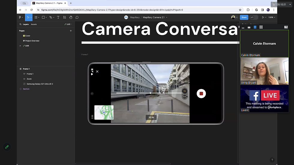
Conversation with Mapillary’s Anna Bryant
In a recent conversation with Anna Bryant from Mapillary, we discussed my experiences as a Mapillary enthusiast and explored the new features of the latest mobile update.
Anna was eager to hear about my adventures and mapping journey, particularly the challenges I faced using only a mobile phone and my determination to overcome them. She introduced me to the new Mapillary mobile update, which includes:
● Improved navigation tools
● Enhanced image capture capabilities
These updates are set to make mapping more efficient and user-friendly.
Our discussion also delved into the broader impact of Mapillary on communities, highlighting how detailed mapping aids urban planning, emergency response, and infrastructure development. Anna’s insights reinforced my belief in the importance of our work and motivated me to keep pushing forward, knowing that every image captured contributes to the greater good.
Training YouthMappers at the University of Cape Coast

I was privileged to join OpenStreetMap Ghana for a visit to the University of Cape Coast (UCC) YouthMappers to train chapter members on how to fly a drone and use Mapillary to capture images.
The training was divided into two comprehensive sessions:
Friday: Theoretical training on drone technology and the principles of Mapillary.
Saturday: Hands-on practice, allowing students to apply what they had learned.
Introducing the students to Mapillary was a particularly rewarding experience. Their enthusiasm and eagerness to apply these new skills underscored the importance of hands-on training in advancing mapping initiatives.
I deeply appreciate OSM Ghana (Mr. Mawutor Stephen Donkor) for the opportunity to learn and explore GIS. I also extend my gratitude to the chapter patrons, Dr. Juliana Amoafa and Dr. Emmanuel Abeashi Mensah, for their support and collaboration.

Mapping Kpando Torkor
My Mapillary walk in Kpando Torkor was a sensational journey for me. The area lacks comprehensive mapping data, hindering infrastructure development and essential service provision.
By capturing street-level imagery with Mapillary, we can bridge this gap and empower communities like Kpando Torkor with valuable mapping data. Accurate mapping information allows local authorities to:
Plan and prioritize infrastructure projects (road repairs, sanitation facilities, healthcare centers).
Support businesses in identifying potential investment areas, ultimately improving livelihoods and quality of life.
The integration of Mapillary data into community decision-making holds immense promise for empowering deprived communities. By harnessing the power of technology and community-driven mapping initiatives, we can pave the way for sustainable development and inclusive growth.


Participatory GIS Workshop in Navrongo
I attended a three-day Participatory GIS (PGIS) workshop in Navrongo, located in the Upper East Region of Ghana. Organized by YouthMappers, the workshop was hosted by CKT-UTAS YouthMappers and brought together other chapters, UBIDS and TACEHUB YouthMappers.
Throughout the workshop, I played a major role in assisting participants. The training covered:
ID Editor and Kobo Collect for data collection
Ethics in mapping and gender considerations in PGIS
Advanced GIS techniques (JOSM, QGIS, data visualization, and management)
The workshop not only equipped participants with essential GIS skills but also fostered a deeper understanding of community-driven mapping initiatives.

Final Thoughts
Reflecting on my journey with Mapillary, I am grateful for the opportunities it has provided and the connections I have made. Every snapshot is a testament to the power of collaboration and technology.
As I continue on this journey, I am reminded that with passion, perseverance, and purpose, anything is possible.
Believe. Belong. Become.

About the Author
Calvin Amevienku is based in Ghana. Holding BSc in Environmental Science. He is a Mapillary enthusiast, amateur drone pilot, and 2023 YouthMappers Leadership Fellow. He is deeply passionate about youth empowerment and community development and strongly shares the principle of thinking globally but acting locally to impact communities, which has a positive influence over the world and humanity at large.


I like games that can be played for a few minutes at a time, and eggy car fits perfectly. Each attempt feels different, making it easy to come back for another run.