
Our journey from OSM To Village
- Kshitij Raj Sharma, Tribhuvan University
- Mar 12, 2020
- 3 min read
I am student of Geomatics Engineering. As a member of GESAN I got to know about open data and how it can be used through various programs with the help of YouthMappers. Today I am going to share my story with you.

Fig: 1.3 On first picture on Right You can See Me, Ward representative, Administration Manager (Medhasi Sir),
Rural Municipality Head (Prem Sir ), Local Leader , And my hardworking Two Friends (Two are Missing )
As soon as I knew about OSM and open data I decided to use open data for rural municipalities and in the tourism sector. When I was in 6th semester I researched about our spatial technologies and GIS-how open data can be used to produce maps and fruitful results. My wonderful friends supported me.
My team and I did GPS surveying in Pokhara for mapping open places. Which will be very useful during crisis, hazard and obviously for an earthquake to quickly find people shelter around their home. Later on, I went to my village and submitted a proposal about mapping our village and making it effective work to rural municipalities, referencing risk and possibilities. I believe mapping is not all about digitizing the places it's about providing meaningful result using them. Now we completed our project on Modi Rural Municipality (Western rural part of Nepal, Parbat District, Gandaki province). We collected the following data (fig:1.1) and made it available to everyone.
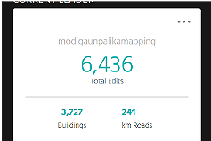


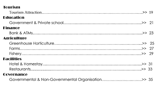
Fig 1.2 and 1.1 (Number of Edits and Table of Contents)
Now rural municipality uses this data to manage their administrations. Knowing how many and what type of agriculture features are available in the field right now and what plans will be helpful for their people, makes it easier to keep their database UpToDate and also greatly helps them to plan for the future of their rural municipality. They are very happy and found it very easy and helpful to monitor, prepare plans and keeping UpToDate data from the field because they don't need to go to the field nowadays. Farmers update their information from the field through mobile access. Then, rural municipality receives the information on their desktop, even sellers and buyers get to know about their products. They are planning to make an admin control panel too for their privacy in some of fields but open data greatly helped them. Training programs for farmers and school headteacher is being organized but we are looking for funding for this. You can see how much editing is done and what type of data is collected in figure 1.2 (above). This is how open data is being used in rural municipalities. This is just an initiation and we are planning to make it big in rural areas of Nepal. We are also making WEBGIS and Mobile application in Annapurna Rural Municipality too. In short, I am trying to link my programming skills with open data for rural municipalities.

In the above picture I was presenting about How WEBGIS and mobile applications can be implemented with OSM on Rural Municipalities. And also submitted a final output of DIGITAL MODI. We prepared Map book and submitted our maps to rural municipalities. Previously, adding presets was not available on osmtracker and hence we made it in Nepali to suit our local community for data collection with the help of coding. I am thankful to my Campus, GESAN , Youthmappers and my Hardworking co-workers: Shraddha Sharma ,Sandhya Dhakal,Sovas Tiwari & Susmina Manandhar.


Comments